Pueblo of Santa Ana, New Mexico
- 2 Dove Road , Santa Ana Pueblo , NM , 87004
- (505) 867-3301
- (505) 867-3395
- Send Email
- www.familysearch.org
- http://www.santaana-nsn.gov
- https://www.legendsofamerica.com/na-puebloindians/
- https://www.bia.gov/tribal-leaders/pueblo-santa-ana
- http://www.nativepartnership.org/site/PageServer?pagename=PWNA_Native_Reservations_SantaAna
- https://kids.kiddle.co/Santa_Ana_Pueblo,_New_Mexico
- https://en.wikipedia.org/wiki/Santa_Ana_Pueblo,_New_Mexico
- https://www.bia.gov/regional-offices/southwest/southern-pueblos-agency
About
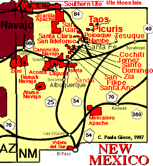
Santa Ana Pueblo (Eastern Keres: Tamaiya [tʰɑmɑjːɑ]) is a census-designated place (CDP) in Sandoval County, New Mexico, United States. As of the 2000 census, had a total population of 479. It is part of the Albuquerque Metropolitan Statistical Area. The Pueblo, named Tamaiya in Keres, administers a total reservation land of 73,000 acres (295 km2) in the Rio Grande valley and is composed of Native Americans who speak an eastern dialect of the Keresan languages.
Click Here to See Google Map & Listing of Churches
Click Picture Below to Access
Click Enlarge Map and then Click Nearby to see all restaurants, gas stations, hotels...etc nearby. This may not appear on phone view.
Video Media
Additional Info
NEW MEXICO RECOGNIZED TRIBES AND PETITIONING TRIBES
https://www.aaanativearts.com/native-amerian-tribes-by-state/new-mexico-indian-tribes-4
For a complete list of Federal and State Tribes Click
https://en.wikipedia.org/wiki/State-recognized_tribes_in_the_United_States
https://www.firstpeople.us/FP-Html-Links/state-recognized-tribes-in-usa-by-state.html
USGS Region : Southwest
Images


Contacts
Ulysses Leon
Governor


